Saturday, August 24, 2013

Tropical Storm Ivo: Storm tracks and predictions


According to information from the Christian Science Monitor, the National Hurricane Center and NOAA is tracking Tropical Storm Ivo. There is a tropical storm warning for the southern portion of the Baja California peninsula in Mexico. It has been stated that a direct landfall isn't likely, but that heavy rain is expected from the storm. This was the map as of 5AM 24 August 2013.


[Image of 5-day forecast of predicted track, and coastal areas under a warning or a watch]


As of 8AM 24 August 2013, computer models have predicted a different storm track. Rather than to barely skirt the coast, the storm is predicted to be further away, and then downgrade to a tropical depression.

In addition to the maps provided, this article from USATODAY on 23 August 2013,
http://www.usatoday.com/story/weather/2013/08/23/tropical-storm-ivo-eastern-pacific-southwest/2691959/

it was predicted that flooding might come to the Southwest USA as a result of the storm. This was a day before.


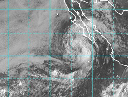
Map of Tropical Storm Ivo, 23 August 2013. The storm is much closer to Cabo San Lucas,Mexico

Could flooding come as a result? It is a possibility. It could happen. It might not. According to the maps and computer models, the storm track predictions have changed, within hours. The storm could still shift.


Tuesday, August 20, 2013

Rainbows.

This video was filmed during a rainstorm. The general idea was to get a video about rainbows and how they form. Rainbows are part of geography too because they are caused by rain, which is a meteorological event.

Video below:


Saturday, August 3, 2013

What geography has done for Mombasa, Kenya.


Along the southern coast of Kenya lies the second largest city in Kenya. A city that dates back to 900 AD.This has historically been a hub for trade, being located along the Indian Ocean. Mombasa has done trade with Persia, India, China, and other places in the east. Major trade items included ivory, gold, and spices.

Because of its location, many empires have wanted control of Mombasa. It has been ruled under different empires throughout its history. It was a strategic location.

However, Mombasa didn't just become a port as a part of some random coincidence. Good ports need good deep water harbors. Mombasa has that. There is a reason this has happened. There is a physical phenomenon called ria. Kilindini Harbor is Mombasa's port. Ria makes this possible. A ria is a deep water channel formed when sea levels rose and covered up a river valley. This has produced a natural harbor, making Mombasa a major port city in East Africa, and a major trading hub in its early days. 

Map of Mombasa.


Valparaiso,Chile: San Francisco of South America.


The city of Valparaiso grew from a small village to one of the most important ports of the Pacific during its glory days. It would be named "Little San Francisco" by sailors passing through this port.

To understand Valparaiso, it is important to understand its geography.

As has been mentioned before in other entries, ports don't just happen. There are certain reasons for these ports being placed where they are. In the case of Valparaiso, it was its deep bay that would provide a natural harbor for this city. This would be helpful for ships looking for a place to dock.


Being a major port in the Pacific, it attracted immigrants from Europe. It was also a major stopover for ships traversing between the Atlantic and Pacific Oceans via the Straits of Magellan. During Valparaiso's golden age, the California Gold Rush was taking place, and Valparaiso was a supplier for ships headed for San Francisco.


There are some parallels. Both cities were founded by the Spanish, as their Spanish names would indicate. Both were once ruled by Spain. Valparaiso and San Francisco are hilly cities. Both cities experienced a severe earthquake in 1906. Both cities are located along a major earthquake fault. Both cities are known for their fog. Both cities have trolleys. Valparaiso has steep stairways in the cityscape, similar to what San Francisco has. Both places has an eclectic mix of architecture. Like San Francisco, Valparaiso has some Victorian architecture. It many ways, Valparaiso is literally like the San Francisco of South America.

As geography helped Valparaiso, it also hurt When the Panama Canal was opened in 1914, ships no longer felt is necessary to traverse the straits of Magellan. Rather, ships could pass through the Panama Canal on their way to other Pacific ports or on their way to Atlantic ports.

However, in recent years, Valparaiso has witnessed a revival, a renaissance of sorts. With Chile being a major fruit exporter, Valparaiso would be given an important hinterland. And the new Panamax ships can't fit through the Panama Canal, so Valparaiso is seeing more shipping traffic, and has regained its importance as a port.